

THE CITY ON THE HILLS TRAIL
Running 31 miles from the Charles River at Millennium Park to Castle Island at Boston Harbor, the City On The Hills Trail is the east-to-west sibling of Boston’s Walking City Trail. It features over 40 green spaces spread across 9 Boston neighborhoods, while visiting some of the highest points in the city—a literal escalation from the Walking City Trail, with more elevation gain and mileage, but the same ease of access to public transit along the way. It was created between late 2023 and spring of 2025 by the same Boston ramblers who established the Walking City Trail.

The City On The Hills Trail is divided into 5 sections that range from around 6 to 7 miles each. You can also split each trail section into two shorter hikes. All of the trail segments are reachable by public transportation at numerous points and include access to food, drinks, and restrooms. You can hike the City On The Hills Trail in incremental pieces, or complete the whole thing over one epic weekend!

SECTION 1. MILLENNIUM PARK, BROOK FARM, HANCOCK WOODS, D. BLAKELEY HOAR SANCTUARY, SKYLINE PARK, KENARD CONSERVATION AREA, LOST POND CONSERVATION AREA (6.9 MILES)
Set off from the city’s far west edge on the banks of the Charles River at Millennium Park and wander through immense, rustling forests in West Roxbury to reach a series of little-known wetlands in Brookline and Chestnut Hill. Boardwalks offer safe and serene passage through towering grasses and reeds, before delivering you to a bustling mall!

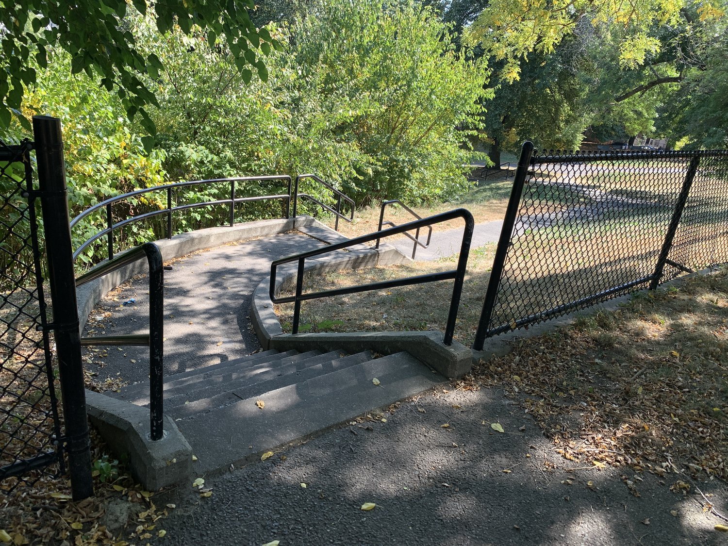
SECTION 2. HAMMOND POND RESERVATION, HOUGHTON’S GARDEN, CHESTNUT HILL RESERVOIR, WALDSTEIN PLAYGROUND, BROOKLINE STAIR PATHS, COREY PARK (5.7 MILES)
Walk alongside some of Boston’s biggest and most heavenly bodies of water before tackling the hilliest piece on the City On The Hills Trail; the famous “stair paths” of Brookline, which roller coaster up and down the local hills. The city overlooks are is worth the climb and the final hidden lookout might just be the best .

SECTION 3. FIDELIS WAY PARK, RINGER PARK, LAWTON PLAYGROUND, KNYVET SQUARE, HALL’S POND SANCTUARY, LONGWOOD MALL, THE RIVERWAY, KEVIN W. FITZGERALD PARK, MISSION HILLTOP, MCLAUGHLIN WOODS (6.4 MILES)
Experience a beautiful intersection of trees, rocks, and built elements as you summit hilltops and ramble through the woods that connect Allston/Brighton, Brookline, and Mission Hill. Climb to that exact landmark itself, before descending to Roxbury Crossing.

SECTION 4. JEEP JONES PARK, HIGHLAND PARK 400 GARDEN, CEDAR STREET COMMUNITY GARDEN, HIGHLAND PARK, 184 HIGHLAND STREET, MALCOLM X PARK, HORATIO HARRIS PARK, TROTTER SCHOOL PLAYGROUND, ELM HILL PARK, CEYLON PARK, RONAN PARK, ALLEN PARK (5.8 MILES)
Follow overlooked paths and stairs in Roxbury and Dorchester to historic buildings, immense puddingstone formations, and big, blooming community gardens; all the while enjoying a transition from the heart of Boston to the salty breeze of the seashore, near Dorchester Bay.
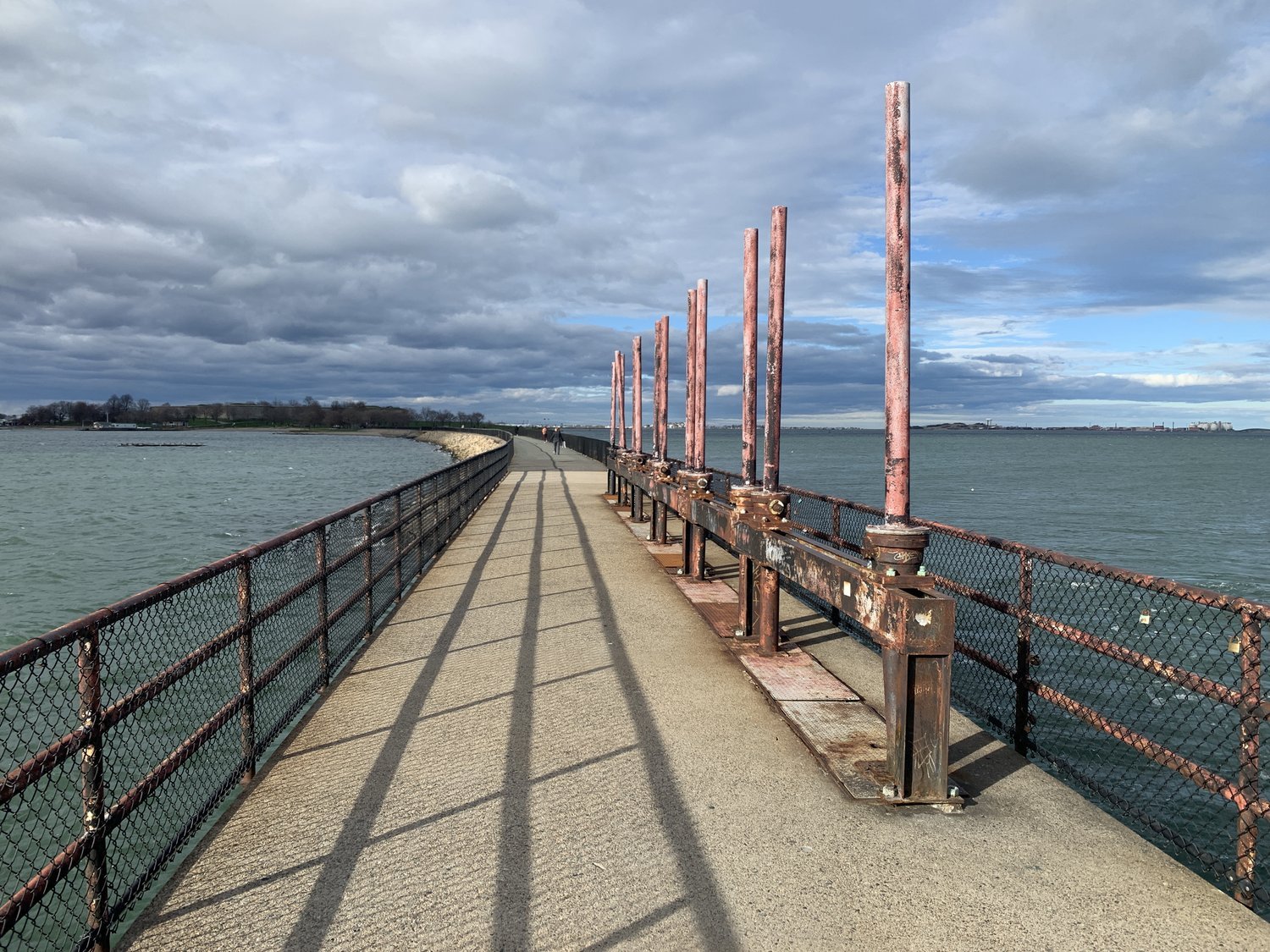
SECTION 5. SAVIN HILLTOP, BOSTON HARBORWALK AT UMASS BOSTON, OLD HARBOR PICNIC AREA, CARSON BEACH, DORCHESTER HEIGHTS MONUMENT, NO MAN’S LAND, MEDAL OF HONOR PARK, PLEASURE BAY, HEAD ISLAND, CASTLE ISLAND (6.4 MILES)
Gaze across Boston Harbor from one of the finest hilltops of Dorchester and then walk around the water by way of sun-splashed paths, city beaches, and the lore-steeped streets of South Boton. From here, all roads lead to the windy causeway that arcs across Pleasure Bay to reach Castle Island.
Ready for a walk? Below you’ll find all of the resources that you need to go for an eye-opening journey on Boston’s City On The Hills Trail; from trail maps to written directions and public transit connections.
TRAIL MAPS
Digital maps are the primary guiding resource for the Walking City Trails. The simplest and most familiar map option for a lot of hikers will be our Google Map of the entire Walking City Trails network. The Walking City Trail, the City On The Hills Trail, and any future trails to come will be featured on our Google Map.
What Google Maps offers in familiarity it can sometimes lack in specificity. Not all of the trail junctions in parks appear on Google Maps. For the most detailed maps of the Walking City Trails, we offer AllTrails maps of each trail; full maps and section maps! You can use these GPS-enabled maps with the free AllTrails app on your phone. Click any of the map links below to get started!

City On The Hills Trail - Full Trail (AllTrails Map)
City On The Hills Trail - Section 1 (AllTrails Map)
City On The Hills Trail - Section 2 (AllTrails Map)
City On The Hills Trail - Section 3 (AllTrails Map)
City On The Hills Trail - Section 4 (AllTrails Map)
City On The Hills Trail - Section 5 (AllTrails Map)
Click here to download a GPX file of the full City On The Hills Trail map for use with alternate GPS apps.

You can also download and print these section maps of the City On The Hills Trail. Each map is 3-4 pages long.
City On The Hills Trail - Section 1 (Printable Map)
City On The Hills Trail - Section 2 (Printable Map)
City On The Hills Trail - Section 3 (Printable Map)
City On The Hills Trail - Section 4 (Printable Map)
City On The Hills Trail - Section 5 (Printable Map)
TRAIL DIRECTIONS

Sometimes it’s nice to pair maps with a secondary source for navigation. To that end, we’ve created turn-by-turn directions for the City On The Hills Trail that include plenty of information about public transit and food connections.
City On The Hills Trail - Section 1 Directions
City On The Hills Trail - Section 2 Directions
City On The Hills Trail - Section 3 Directions
City On The Hills Trail - Section 4 Directions
City On The Hills Trail - Section 5 Directions
TRAIL CONDITIONS
The City On The Hills Trail is 31.1 miles long with around 1,800 feet of vertical elevation gain from start to finish. The trail surfaces include sidewalks, dirt paths, gravel paths, rocky and rooty paths, stairs, boardwalk segments, and bridges. Section 1 is the longest section of the trail, Section 2 is the hilliest and shortest section of the trail, and Section 5 is the most level section of the trail (but there are still a few hills.)
PUBLIC TRANSIT

You can connect to each section of the City On The Hills Trail by using the MBTA transit system. Below you'll find transit connections to each section trailhead. In the directions for each trail section, there are additional transit connections listed for the "halfway" points near the middle of the trail’s five sections. In other places, you have to go rogue and venture off-trail to reach local buses or trains.
City On The Hills Trail Section 1 trailhead, Millennium Park (West Roxbury)
- Bus lines: 36
City On The Hills Trail Section 2 trailhead, Chestnut Hill Square mall (Chestnut Hill)
- Bus lines: 60
City On The Hills Trail Section 3 trailhead, Washington Street Station (Allston/Brighton)
- Bus lines: 65
- Subway: Green Line at Washington Street Station
City On The Hills Trail Section 4 trailhead, Roxbury Crossing Station (Roxbury)
- Bus lines: 15, 19, 22, 23, 28, 44, 45, 66
- Subway: Orange Line at Roxbury Crossing Station
City On The Hills Trail Sections 5 trailhead, Savin Hill Station (Dorchester)
- Bus lines: 18
- Subway: Red Line at Savin Hill Station
City On The Hills Trail’s end at Castle Island (South Boston)
- Bus lines: 7, 9, 10, 11
WHAT TO PACK

One of the most underrated perks of taking a hike through a city is that you don't need to pack as much gear for your hike as you would in the backcountry, and the gear that you should bring won't cost nearly as much as backcountry gear. Usually this means that you'll be hiking with a lighter daypack. And if you do happen to leave something behind, chances are you can find it in a store near the trail. That said, an urban hike on the Walking City Trails network will be more enjoyable if you pack the following items...
- Comfortable walking shoes and thick socks
- An extra pair of socks, just in case
- Sunblock and a season-appropriate hat
- At least 1 liter of drinking water
- Trekking pole(s) for stability on sloped surfaces
- 3 upper body layers, such as a t-shirt, a fleece, and a rain jacket
- A first aid kit with bandages and blister tape
- A headlamp or flashlight, if you're hiking into the evening or before sunrise
- A portable phone charger/battery, if you plan to navigate with your phone
